Delhi Gets Rain Relief After Week-Long Heatwave, Temperatures Dip


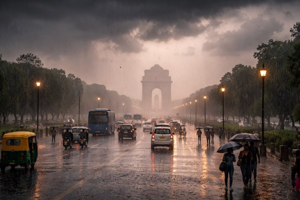
New Delhi: After nearly a week of intense heat, with temperatures nearing 44 degrees Celsius, residents of New Delhi finally experienced relief on Wednesday morning as rainfall swept across several parts of the city.
Showers began early, with low-hanging cloud cover taking over the skies and bringing down both temperatures and humidity.
Areas such as Kushak Road and Lutyens’ Delhi witnessed dark clouds, strong winds and steady rain, marking a sharp shift in weather conditions.
The capital had been under a “yellow alert” due to heatwave conditions, with temperatures ranging between 42 degrees Celsius and 45 degrees Celsius in recent days. However, as forecast by the India Meteorological Department (IMD), a western disturbance triggered sudden atmospheric changes, leading to a noticeable drop in temperature.
The day’s maximum temperature, earlier expected to reach 41 degrees Celsius, is now likely to remain around 38 degrees Celsius.
According to the Regional Weather Forecast Centre in (RWFC) New Delhi, light to moderate rainfall accompanied by thunderstorms, lightning, and gusty winds of 30–40 kmph was expected across Delhi and the National Capital Region (NCR) during the morning hours.
“Light to moderate rainfall accompanied by thunderstorms, lightning, and gusty winds (30–40 kmph) is very likely over Delhi and NCR, as well as in parts of Haryana, Uttar Pradesh, and Rajasthan,” RWFC said in a statement.
Rainfall is also forecast in several Haryana districts, including Panipat, Hisar, Jind, and Bhiwani, as well as parts of western Uttar Pradesh.
The showers, along with strong winds, brought a visible change in Delhi’s weather, leaving roads wet and skies overcast.
Meanwhile, data from the Central Pollution Control Board (CPCB) showed the city’s air quality index (AQI) at 260, categorised as “poor” category.
Speaking on Tuesday, IMD scientist Akhil Srivastava highlighted weather alerts across northern, eastern, and western India. He noted that thunderstorm activity is expected in Punjab and Haryana in the coming days, which could bring temperatures down by 2–4 degrees Celsius.
He also mentioned that an orange alert has been issued for severe thunderstorms in Bihar, Gangetic West Bengal, Odisha, and Jharkhand. Meanwhile, northeastern states are likely to receive heavy to very heavy rainfall over the next week.
“In the northern region, heatwave conditions have persisted for the past 15 days. However, due to a western disturbance centred around 66°E longitude, thunderstorm activity is expected over the Western Himalayas and adjoining plains. Alerts have been issued for Jammu and Kashmir, Himachal Pradesh, and Uttarakhand for thunderstorms and hailstorms. Punjab and Haryana may witness thunderstorms with wind speeds of up to 60 kmph, leading to a drop in maximum temperatures by 2–4°C over the next three days,” he said.
Looking ahead, heatwave conditions are expected to persist for now in parts of Rajasthan, Madhya Pradesh, Vidarbha, and Marathwada, but are likely to gradually ease.
Eastern India remains under an orange alert for severe thunderstorms, while northeastern regions are forecast to witness heavy to extremely heavy rainfall, with red alerts issued in several areas.
(DD News)