The Bay of Bengal Depression weakens into a Well-Marked Low Pressure Area: IMD
New Delhi: The Indian Meteorological Department (IMD) has been continually monitoring the depression that formed over the Bay of Bengal.
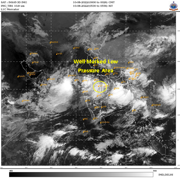
The IMD took to Twitter and shared an aerial map showcasing the movement of the depression wind systems.
According to the weather department, the wind systems have been moving towards the interiors of the country. Besides, they reported that the depression significantly weakened into a well-marked low pressure area as on Wednesday, August 10, 2022.
The IMD informed how the depression is continuously moving towards interiors of the country and is expected to further weaken into a low pressure area during the next 24 hours.
“Depression weakened into a Well Marked Low Pressure Area at 0530 hours IST of today, the 10th August, 2022, over Chhattisgarh and adjoining east Madhya Pradesh. It is likely to move west-northwestwards and gradually weaken into a low pressure area during next 24 hours,” the IMD informed.
These wind systems are also likely to affect the monsoon conditions over central India. The IMD shared spatial rainfall distribution map on Twitter with a caption that read, “Active monsoon conditions lies over Central India with a Well Marked Low Pressure Area over East Madhya Pradesh and neighbourhood and a Low Pressure Area lies over Saurashtra and the adjoining Northeast Arabian Sea.”
“Subdued rainfall activity likely to continue over Uttar Pradesh, Bihar and North-eastern states during the next 3 days,” it added.
(Avya Mathur)


