Parting kick: The US’s map of India leaves, China, Pakistan stunned


Virendra Pandit
New Delhi: With the US-Pakistan’s latest honeymoon over, Washington’s parting kick to India’s hostile neighbour left Pakistan, as also China, red-faced after the US published a map showing the entire Jammu and Kashmir, including Pakistan-occupied Kashmir (PoK), and Aksai Chin, as parts of Indian territory.
Only on Friday, the Pakistan Army’s puppet Prime Minister, Shehbaz Sharif, had boasted that his country would remain incomplete until it ‘acquired’ the entire J&K.
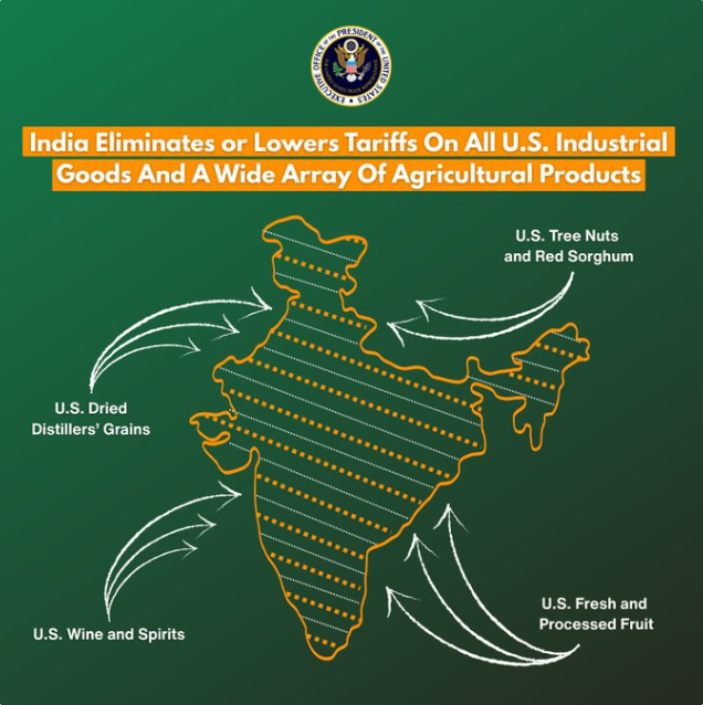
A day after, while announcing the interim trade deal, the US Trade Representative’s office released a map of India showing the entire J&K and PoK as part of the Indian territory. Moreover, it also included Aksai Chin, located in the northeastern part of Ladakh, which China claims as its territory.
As New Delhi and Washington announced the framework for an interim deal on Saturday, a map of India shared by the Trump administration quietly took centre-stage and garnered attention on social media.
India has always asserted that the entire J&K is an inalienable part of the country. But, still, it marks a departure from the US’s earlier stance. Whether deliberate or incidental, it has sent a strong diplomatic signal to Pakistan and China—that the US leadership is in line with India’s map.
On earlier occasions, the maps released by the US or its State Department used to have a clear demarcation of the PoK, in line with Pakistan’s concerns. The latest map released by the Trump administration clearly thumbs nose at Pakistan’s claims.
In 2025, Trump sought to re-hyphenate India and Pakistan, reversing the de-hyphenation policy started by the George W. Bush administration and followed by subsequent presidents. But Washington changed its stance now.
In fact, the Ministry of External Affairs (MEA) has consistently objected to the incorrect depiction of India’s borders — specifically Jammu and Kashmir and Arunachal Pradesh — on maps used by the US State Department and other global agencies. The US’s latest move finally takes into consideration India’s longstanding concern, the media reported.
Over the past six months, Pakistani diplomacy has been on overdrive, with its self-proclaimed “Field Marshal,” Army chief Syed Asim Munir visiting the US thrice. He also held two meetings with Trump, including a much-publicised lunch in June 2025. It marked the first time a US President engaged Pakistan’s army chief alone, without any civilian leadership present.
Whether the new map marks a subtle shift in US policy by tilting towards India remains to be seen. Whether it is a tactical gesture aimed at placating India after a year of friction with Trump, or merely a bureaucratic oversight, remains open to interpretation. What is clear, however, is itt reinforces India’s claims on its most sensitive territorial issues.